[dropcap style=”font-size:100px;color:#992211;”]N[/dropcap]ASA satellites saw Cyclone Freda’s widening eye
Tropical Cyclone Freda intensified over the last couple of days in the warm waters of the Southern Pacific Ocean, and NASA’s TRMM and Aqua satellites measured the rainfall within the storm, and noticed the eye grew larger.
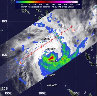
When NASA’s Tropical Rainfall Measuring Mission (TRMM) satellite passed over Cyclone Freda on Dec. 30 at 1004 UTC (5:04 a.m. EST) data indicated that the heaviest rainfall was occurring southeast of the center. Rainfall in that area was falling at a rate of 2 inches/50 mm per hour (red). TRMM data showed a 10 nautical-mile (11.5 mile/18.5 km) wide eye in Freda’s center. TRMM also showed strong banding of thunderstorms wrapping around Freda’s center, indicative of a powerful cyclone.
On Dec. 30 at 0300 UTC (Dec. 29 at 10 p.m. EST/U.S.) Freda’s maximum sustained winds were near 100 knots (115 mph/185.2 kph). It was located about 590 nautical miles northwest of Noumea, New Caledonia, near 14.3 south latitude and 160.7 east longitude. Freda was moving to the south-southeast at 7 knots (8 mph/13 kph).
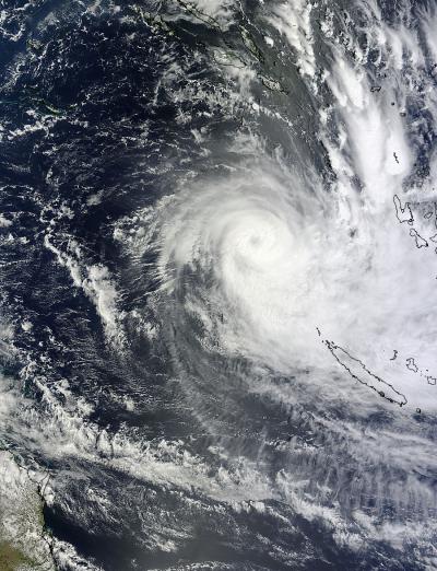
Later that day, another NASA satellite passed over Cyclone Freda and captured a visible image of Freda’s cloud shield. The Moderate Resolution Imaging Spectroradiometer (MODIS) instrument that flies aboard NASA’s Terra satellite captured a visible image of Tropical Cyclone Freda over the Solomon Islands on Dec. 30, 2012 at 2345 UTC (6:45 p.m. EST/U.S.). MODIS imagery showed that Freda’s eye had widened to 13 nautical miles (15 miles/24 km), although the spiral banding of thunderstorms had diminished. MODIS imagery and TRMM imagery are created at NASA’s Goddard Space Flight Center in Greenbelt, Md.
On Dec. 31 at 0300 UTC (Dec. 30 at 10 p.m. EST/U.S.) Freda’s maximum sustained winds increased to 105 knots (120.8 mph/194.5 kph). It was located about 465 nautical miles (535.1 miles/861.2 km) northwest of Noumea, New Caledonia, near 16.7 south latitude and 161.2 east longitude. Freda was moving to the south at 6 knots (7 mph/11 kph).
Special Sensor Microwave Imager Sounder (SSMIS) data from the DMSP satellite showed that increasing northwesterly wind shear (up to 25 knots/28.7 mph/46.3 kph) was eroding Freda’s main convection (rising air that forms the thunderstorms that make up Freda) north of the center. SSMIS data are produced as part of NASA’s MEaSUREs Program.
At 1332 UTC Dec. 31 (8:32 a.m. EST/U.S.) or 12:32 a.m. VUT local time, Jan. 1, 2013, the Vanuatu Meteorology and Geo-Hazards Department (VMGD), Port Vila issued an advisory on Tropical Cyclone Freda. The VMGD bulletin noted “central and southern islands of Vanuatu may receive strong to gale force winds of 60 to 90 KM/HR within the next 36 to 48 hours. Heavy rainfall is expected over central and southern Vanuatu. Flooding is also possible over low lying areas and areas close to river banks.” For updated forecasts, visit: http://www.meteo.gov.vu/.
Freda is expected to continue moving southward and turn to toward New Caledonia on Jan. 2, 2013. During the latter half of that period, Freda will be moving over cooler waters and into an area of higher wind shear, which forecasters at the Joint Typhoon Warning Center expect to weaken the storm.
As Freda approaches New Caledonia, residents there can expect the surf to become increasingly rough and periods of heavy rainfall and gusty winds, especially on Wednesday and Thursday, Jan. 2 and 3. For New Caledonia forecasts (in French) from Meteo France, visit: http://www.meteo.gov.vu/.
Source: NASA/Goddard Space Flight Center. Eurekalert

The aim of art is to represent not the outward appearance of things, but their inward significance. – Aristotle


