Flying robot cameras, once the preserve of sci-fi, enter final development stages. A recent viral YouTube video showed formation-flying quadrocopters with anti-collision technology and distance-sensors, now similar technology ushers in an age of remote surveillance.
The information reprinted below comes direct from the company's press release, so do take the obligatory closing paragraph about the fluffy, humanitarian applications that the technology could be used for. Fill in you own distopian scenarios yourself.
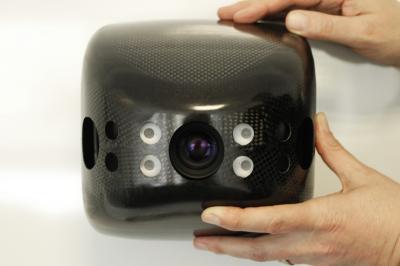
 A CMOS sensor developed by researchers at the Fraunhofer Institute for Microelectronic Circuits and Systems IMS in Duisburg lies at the heart of the anti-collision technology. "The sensor can measure three-dimensional distances very efficiently," says Werner Brockherde, head of the development department. Just as in a black and white camera, every pixel on the sensor is given a gray value. "But on top of that," he explains, "each pixel is also assigned a distance value." This enables the drones to accurately determine their position in relation to other objects around them.
Sensor has a higher resolution than radar
The distance sensor developed by the IMS offers significant advantages over radar, which measures distances using reflected echoes. "The sensor has a much higher local resolution," says Brockherde. "Given the near-field operating conditions, radar images would be far too coarse." The flying robots are capable of identifying even small objects measuring 20 by 15 centimeters at ranges of up to 7.5 meters. Moreover, this distance information is then transmitted at the very impressive rate of 12 images per second.
The 3D distance sensors are built into cameras manufactured by TriDiCam, a spin-off company of Fraunhofer IMS. Jochen Noell, TriDiCam's managing director, admits: "This research project has presented us with new challenges as regards ambient operating conditions and the safety of the sensor technology."
Conducting intelligent aerial surveillance of major events is not the only intended use for flying robots. They could also be of benefit to disaster relief workers, and likewise to urban planners, who could utilize them to produce detailed 3D models of streets or to inspect roofs in order to establish their suitability for solar installations.
Whether deployed to create virtual maps of difficult-to-access areas, to monitor construction sites or to measure contamination at nuclear power plants, these mini UAVs could potentially be used in a wide range of applications, obviating the need for expensive aerial photography and/or satellite imaging.
Source and Image: Fraunhofer-Gesellschaft

The aim of art is to represent not the outward appearance of things, but their inward significance. – Aristotle


